


Trails
For lovers of hiking and trekking, Melgaço offers a diverse network of trails and mountain trails, well signposted and integrated into breathtaking landscapes. There are options for all levels — from accessible routes in riverside areas to more demanding routes on mountain slopes and ridges. The trails cross native forests, levadas, traditional villages and natural viewpoints, providing unique experiences in harmony with the local biodiversity.
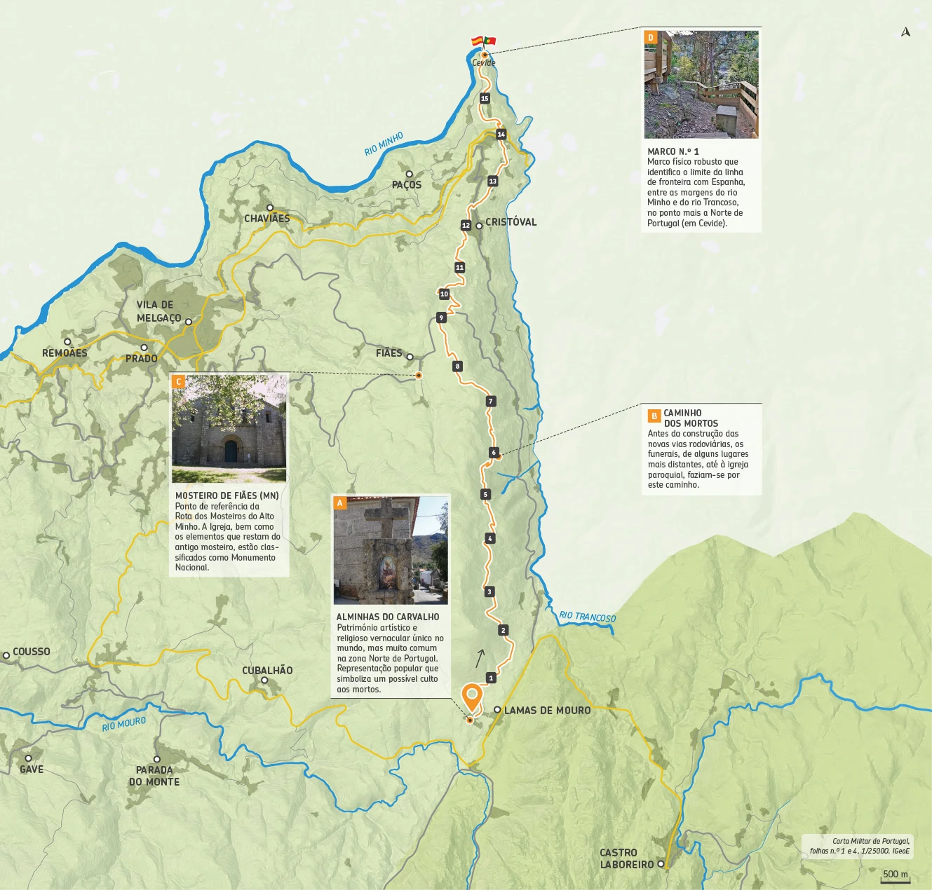
PR I: Lamas de Mouro - Cevide

This is a linear route of about 16 km. Portugal is the only country in the world that has them as part of its cultural heritage, although they are much more common in the North. Usually located on the side of rural roads and at crossroads, they are popular representations of the souls in Purgatory who beg for prayers and alms for the souls of the deceased in general, and therefore symbolize a possible cult to the dead.
As you walk along the paths of the village and the surrounding agricultural mosaic, delimited by old loose stone walls, you follow a dirt road, surrounded by low bushes, that leads to the ruins of an old Forest Ranger’s house. In this area, there is also the symbolic value of walking along a path known as the “path of the Dead” (B). This name comes from the fact that, before the construction of the new highways, funerals from some more distant places to the parish church were carried out along this path. The deceased were transported in ox carts, taking hours to reach the main church.
Fazendo um pequeno desvio do percurso marcado, é possível encontrar um dos pontos de referência da Rota dos Mosteiros do Alto Minho, o Mosteiro de Fiães (C). Com a extinção das ordens religiosas em 1834, o mosteiro tem então a comunidade reduzida a dois monges, tendo ainda um terceiro religioso, mas a viver com os seus familiares por ter uma doença contagiosa. O mosteiro sofreu várias campanhas de restauro, que não alteraram significativamente a estrutura, que manteve, à vista, a maioria dos seus elementos medievais. A Igreja de Fiães bem como os elementos que restam do antigo mosteiro estão classificados como Monumento Nacional.
A partir daqui o caminho descendente leva-nos ao lugar de Cevide, o ponto mais a Norte de Portugal. É nesta aldeia onde podemos visitar o marco de fronteira n.º 1 com Espanha (B) e dar um saltinho ao país vizinho percorrendo o novo passadiço ou a caneja do contrabando.
Fauna: Vaca-loura (Lucanus cervus), Gineta (Genetta genetta), Fuinha (Martes foina)
Flora: Escambrão (Pyrus cordata), Violeta-dente-de-cão (Erythronium dens-canis), Anémona-dos-bosques (Anemone trifolia)
Starting Point: Lamas de Mouro 42°03’04.0″N 8°11’58.3″W
Arriving Point: Cevide 42°03’04.0″N 8°11’58.3″W
Distance: 15,8 Km – Linear
Duration on Foot: 05h30
Duração on Horse: 02h15
Duração on Bike: 01h20
Difficulty: IV – Hard
Max Height: 1062m
Min Height: 77m
Accumulated positive unevenness: 1122m
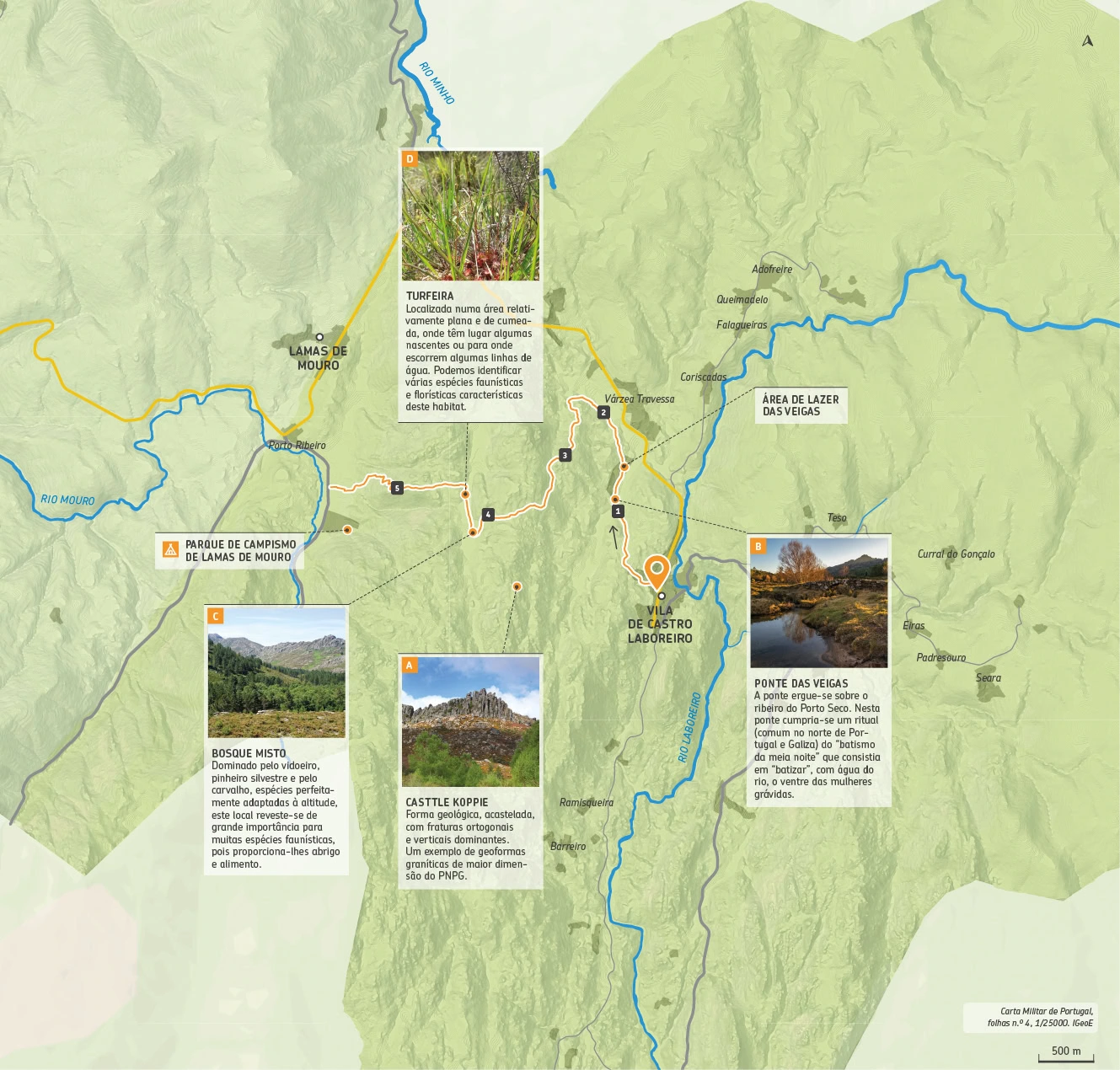
PR II: Castro Laboreiro - Lamas de Mouro

The trail begins in the village of Castro Laboreiro, at the crossroads of the church (next to the information panel). From here, you follow a gentle path, following roughly the same elevation, providing some scope for observation.
If you look to your left, looking at the horizon, on the slope of the Serra da Peneda, you will see an important rock formation, the result of granite weathering, the Casttle koppie (A) – a particular form of inselberg (“island mountain”), castellated with dominant orthogonal and vertical fractures. One of the best examples of large granite geoforms in the Peneda-Gerês National Park, and therefore an element to be considered in the interpretation of the geological heritage of this region.
Shortly after, you cross the Porto Seco stream, the old Ponte das Veigas (B) and arrive at the leisure area of the same name. This is a large space with a picnic area, several wooden benches and tables, as well as a playground and a multi-sports court. A little before Vido, a hill emerges that takes us on a gradual climb from 1,000 to 1,100 meters in altitude. Upon reaching the highest point (approx. 1,100 meters), you can enjoy a forest with wild pines and birches (C), an important shelter for several species of fauna.
Immediately after the forest, the trail heads north, skirting a small wetland area (hygropeat complex) (D). A few meters later, a steep descent begins, through bushes and rocky outcrops, to the Porta de Lamas de Mouro, an informative and interpretive tourist space about the National Park.
Starting Point: Castro Laboreiro 42°01’49.9″N 8°09’33.6″W
Arriving Point Lamas de Mouro (Porta PNPG) 42°02’20.7″N 8°11’45.0″W
Distance: 6,5 Km – Linear
Duration on Foot: 02h45
Duration on Horse: —
Duration on Bike: —
Difficulty: III – a bit easy
Max Height: 1095m
Min Height: 869m
Accumulated positive unevenness: 322m
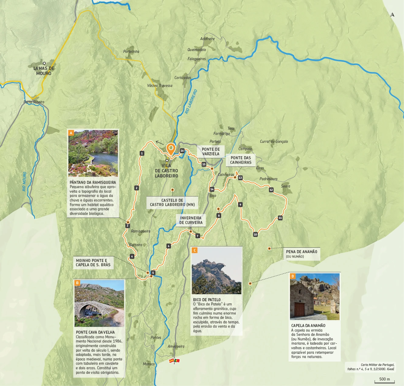
PR III: Trilho Castrejo

The “Castrejo Trail” begins in the village of Castro Laboreiro, at the crossroads of the church (next to the information panel). It follows old paths dating back to the Middle Ages, of which some old cobblestones and arched bridges that connected the Brandas to the Inverneiras remain.
These population centers represent a unique form of land occupation. The Brandas are villages located on high, sunny lands, more suited to the hot climate; and the Inverneiras are villages located in sheltered valleys that allowed the Castrejos to protect themselves from the harsh winter weather in the mountains. These are paths full of history and stunning natural wealth. Sometimes you cross leafy oak forests; other times low, flowering scrublands and even biodiverse riparian galleries. We travel through a territory where human occupation has been carried out in close harmony with the environment, which is modernly called “sustainable development”, but which has long been the way of being and living of the Castro populations in their relationship with the Mountain and Nature.
An important cultural heritage site stands out, of which the Cava da Velha bridge (B) (National Monument), the mill, bridge and Chapel of S. Braz are good examples. Next to the latter, the water mill, used ingeniously in the past to grind cereals, further enriches the landscape. Also worthy of note is the geological formation known as “Bico de Patelo” (C). The granite outcrops also provide a strong image of this mountain landscape.
Fauna: Mountain goat (Capra pyrenaica), Water thrush (Cinclus cinclus), African wall lizard (Psammodromus algirus)
Flora: Strawberry tree (Arbutus unedo), Honeysuckle (Lonicera periclymenum), Divine root (Armeria humilis)
Starting point: Vila – Castro Laboreiro 42°01’49.9″N 8°09’33.6″W
Arrival Point: Vila – Castro Laboreiro 42°01’49.9″N 8°09’33.6″W
Distance: 16,7 Km – Circular
Duration on Foot 06h00
Duration on Horse: —
Duração on Bike: —
Difficulty: IV – Hard
Max Height: 1119m
Min Height: 749m
Accumulated positive unevenness: 839m
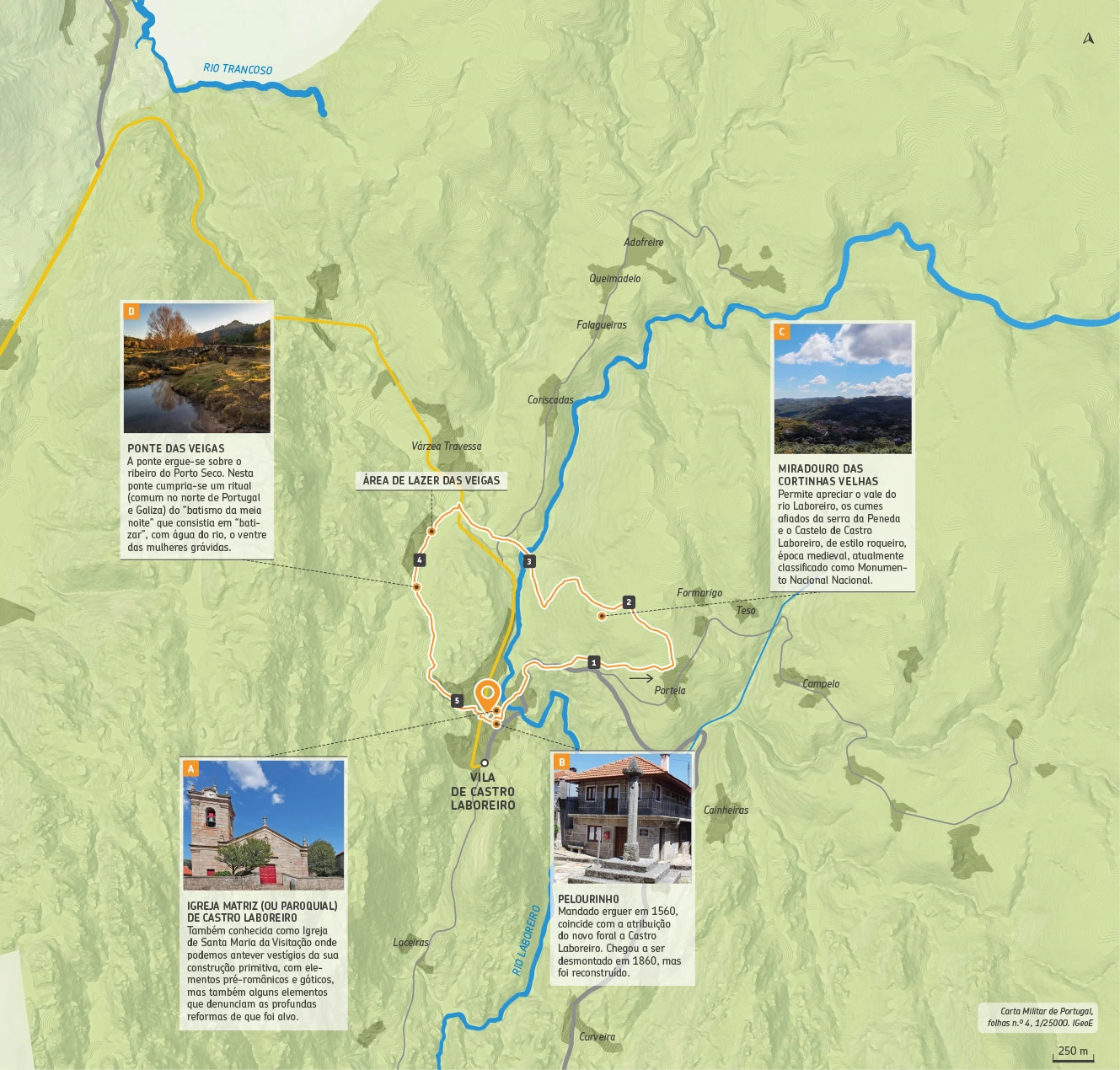
PR IV: Trilho Interpretativo de Castro Laboreiro

This trail begins in the village of Castro Laboreiro, at the crossroads of the church (next to the information panel) and continues towards the main church (A). Next to the main church (although this is not the original location), we can see the pillory (B), built in 1560, which coincides with the granting of the new charter to Castro Laboreiro.
Along an old path, flanked by an important oak grove, the climb is towards Branda da Portela, located at the gates of the emblematic Castro Laboreiro plateau. This path was used by cattle and people, between the plateau and the valley (occupied in the coldest and harshest winter months). A way of life that reflects an austere but efficient way of managing natural resources.
Upon reaching the highest point of the trail (1,100m above sea level), a natural viewpoint emerges amidst the granite blocks (C). It allows you to appreciate the valley of the Laboreiro River, the sharp peaks of the Peneda mountain range and the Castro Laboreiro castle, a medieval rock-style castle, currently classified as a National Monument and the first fortress in the dry border of Alto Minho. These are the “ingredients” that make this one of the most beautiful scenes on this trail.
The descent into the valley allows you to glimpse new landscapes, such as when you look over the walls and see the beautiful lime meadows. In winter, the meadow is limed – a thin sheet of water constantly runs over it in order to keep the temperature above 0º C, thus preventing the formation of frost that would burn the grass. Continue to Veigas (D) where you will have the opportunity to wander through history across the Veigas bridge. Shortly after, the trail ends at the starting point.
Fauna: Water lizard (Lacerta schreiberi), Robin (Erithacus rubecula), Badger (Meles meles)
Flora: Black oak (Quercus pyrenaica), Spatulate saxifrage (Saxifraga spathularis), Martagão (Lilium martagon)
Starting Point: Vila – Castro Laboreiro 42°01’49.9″N 8°09’33.6″W
Arrival Point: Vila – Castro Laboreiro 42°01’49.9″N 8°09’33.6″W
Distance: 5,2 Km – Circular
Duration on Foot: 02h00
Duração on Horse: —
Duração on Bike: —
Difficulty: II – easy
Max Height: 1096m
Min Height: 934m
Accumulated positive unevenness: 223m
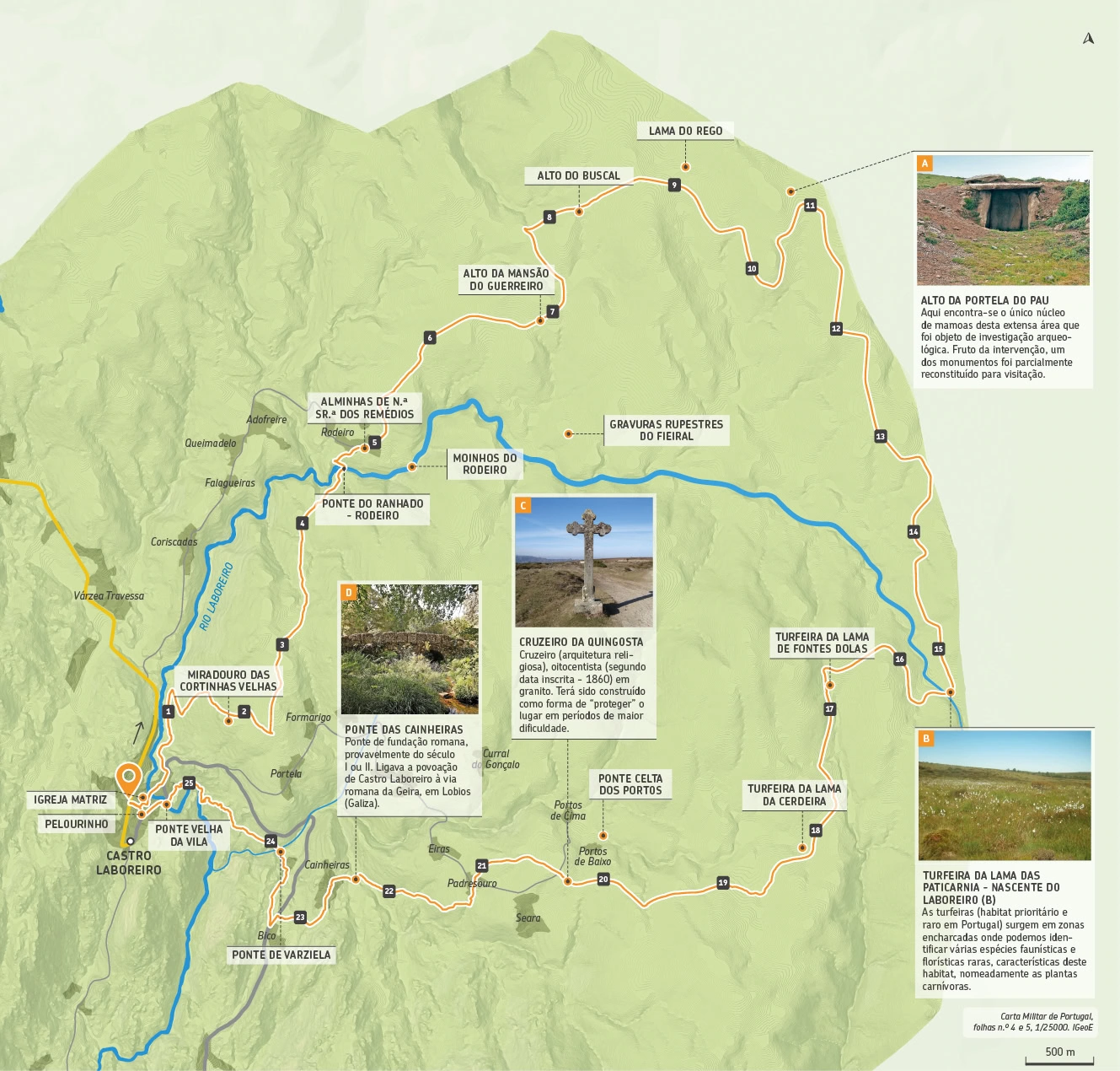
PR V: Megalitismo
This route starts in the village of Castro Laboreiro and heads towards Branda do Rodeiro. This route allows you to “travel” through the Castro plateau, a territory that still preserves remarkable traces of the past.
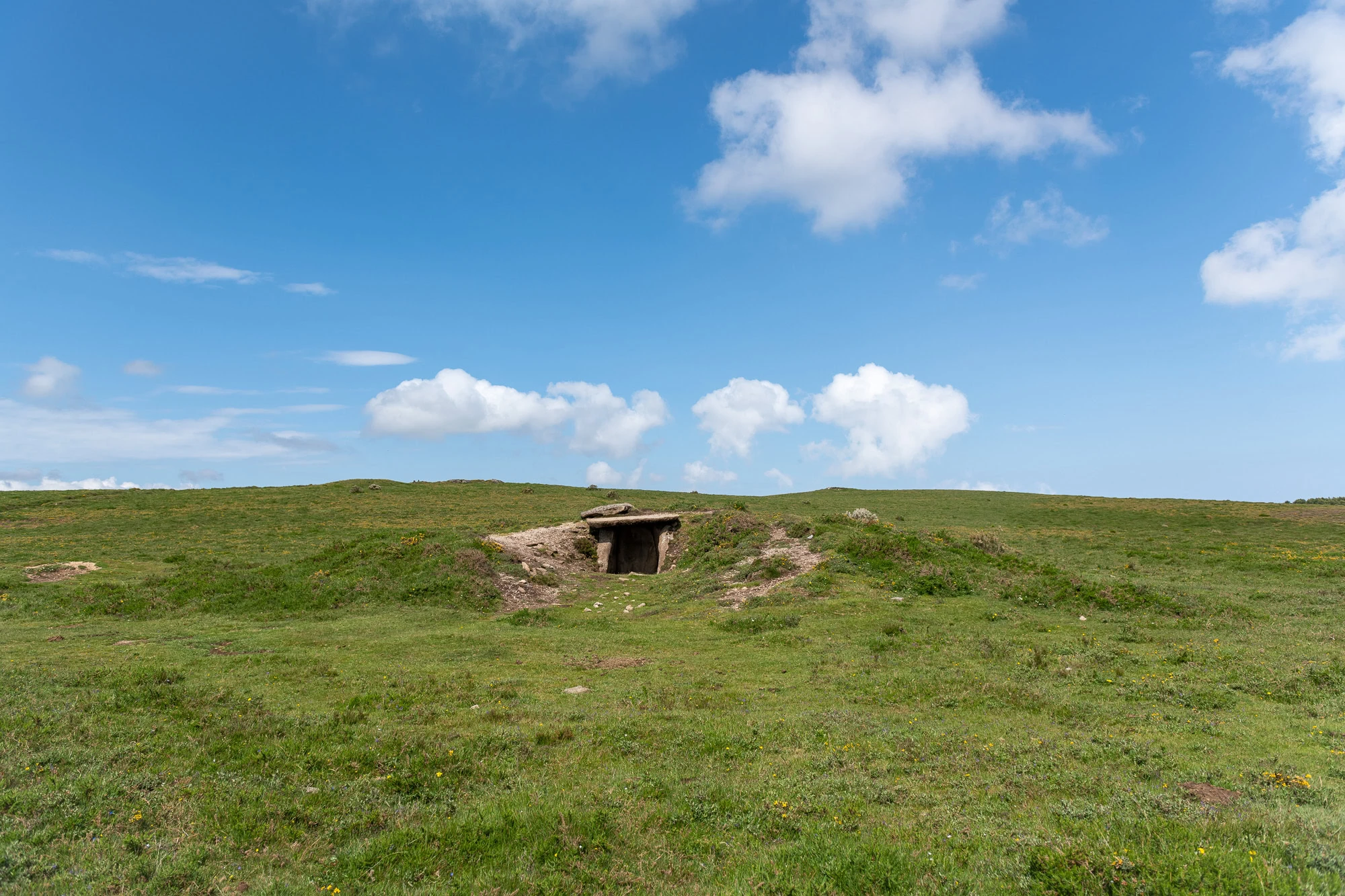
As you enter the plateau that develops in the Serra do Laboreiro up to the so-called “raia seca”, the border line with Galicia, you will find a sacred prehistoric space witnessed in the landscape by dolmens or dolmens that are grouped together in relatively restricted nuclei, forming a large Necropolis, which indicates the collective and symbolic importance of this place. The Megalithic Necropolis dates from the Middle/Late Neolithic to the Bronze Age and is one of the largest and most important in the Iberian Peninsula. The other monuments are spread over an area of around 50 km2, at an altitude of over 1,100 meters and, thanks to this location, are in good condition. Most of the mounds still preserve the megalithic dolmen.
O núcleo do Alto da Portela do Pau (A) é o único desta extensa área que foi objeto de investigação arqueológica. Fruto da intervenção, um dos monumentos foi parcialmente reconstituído para visitação. Uma particularidade são os motivos gravados e ténues vestígios de pintura nos esteios ainda visíveis. O monumento com maior destaque neste local é a Mota Grande, sendo esta a maior mamoa do planalto, já em território galego.
Este património cultural convive harmoniosamente com um outro tesouro do património natural, as Turfeiras Atlânticas (B) que só podem ser encontradas em zonas de montanha acima dos 800 metros e em zonas encharcadas. Outrora abundantes, hoje, são um habitat raro em Portugal, mas com enorme importância ecológica. O Percurso prolonga-se até outras Brandas e passa já por algumas inverneiras, para encontrar o caminho de regresso ao ponto de partida.
Fauna: Tartaranhão caçador (Circus pygargus), Cartaxo Nortenho (Saxicola rubetra), Lobo Ibérico (Canis lupus signatus)
Flora: Bolas-de-algodão (Eriophorum Angustifolium), Orvalhinha (Drosera rotundifólia), Erva-Loira-de-Melgaço (Senecio legionensis)
Starting Point: Vila – Castro Laboreiro 42°01’49.9″N 8°09’33.6″W
Arrival Point: Vila – Castro Laboreiro 42°01’49.9″N 8°09’33.6″W
Distance: 25,7 Km – Circular
Duration on Foot: 07h30
Duration on Horse: 02h30
Duration on Bike: 03h15
Difficulty: IV – hard
Max Height: 1274m
Min Height: 884m
Accumulated positive unevenness: 682m
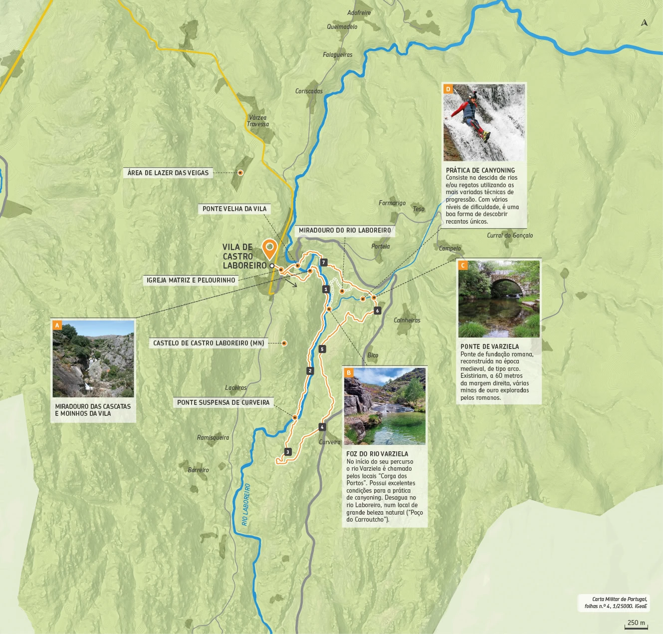
PR VI: Rio Laboreiro

This trail provides a pleasant walk along the Laboreiro River, which rises on the Castro plateau, on the western slope of the Serra do Laboreiro, close to the Galician border, and crosses the entire territory. As it turns south, the river marks the border between the Peneda and Laboreiro mountain ranges.
In its final stretch, of around 14 km, it marks the border between Portugal and Spain and flows into the Lima River. The trail begins in the town of Castro Laboreiro, shortly after which it reaches the Museum Centre and, shortly after, a natural viewpoint (A) that provides a panoramic view of the Laboreiro waterfalls and the town’s old bridge. In this mountainous location, this waterfall crosses a steep drop and falls from the top of high rocky cliffs.
This panoramic view also includes the old water mills used in the past to grind rye, an essential raw material for making Rye Bread, the famous Castrejo Bread. Winding down the mountain, its banks are connected by bridges that various civilizations have built over time and that remain here. At the end of the route, there is the opportunity to cross the Varziela Bridge (C). Of the many historic bridges that remain, the Varziela Bridge is the one that shows the greatest signs of having been built in the medieval period. However, some authors point to the medieval remodeling of old Roman bridges, which is what happened with this bridge as well.
These are some examples of the endless opportunities that Rio de Janeiro offers. Throughout its length, it has clear natural pools surrounded by giant cliffs, breathtaking waterfalls, perfect ingredients for canyoning (D), a recreational exploration activity that allows us to visit and travel through the most beautiful and hidden corners of this mountain river.
Fauna: Otter (lutra lutra), Water mole (Galemys pyrenaicus), River trout (salmo trouta fario)
Flora: Alder (Alnus glutinosa), Woodland heather (Senecio nemorensis), White heather (Erica arborea)
Starting Point: Vila – Castro Laboreiro 42°01’49.9″N 8°09’33.6″W
Arrival Point: Vila – Castro Laboreiro 42°01’49.9″N 8°09’33.6″W
Distnce 8,1 Km – Circular
Duration on Foot: 04h00
Duration on Horse: —
Duration on Bike: —
Difficulty: V – very hard
Max Height: 980m
Min Height 789m
Accumulated positive unevenness: 486m
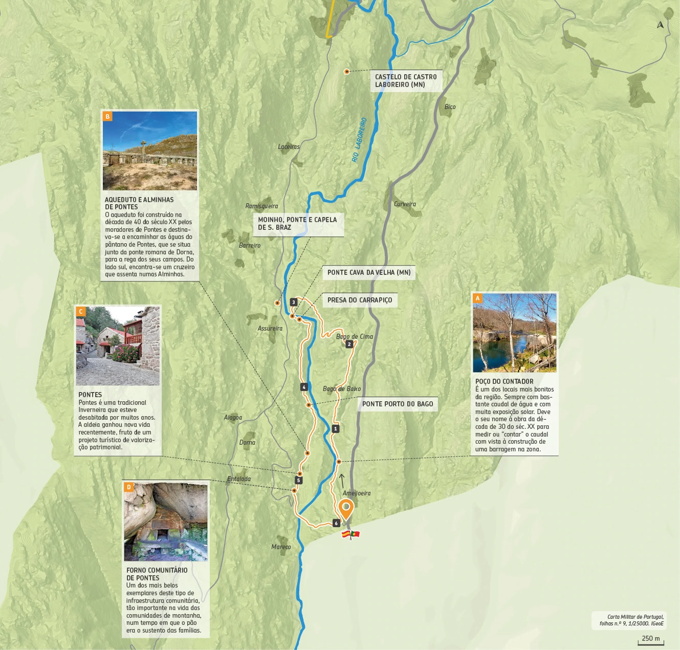
PR VII: Inverneiras

As you walk along the corners of this trail, you will be able to explore the Vale das Inverneiras. The Laboreiro River, as it turns south, carves out a valley of vital importance for the survival of the inhabitants of this territory.
Here, in deeper and more sheltered places, are the inverneiras, small population centers made up essentially of austere buildings, which served as a counterpoint to the brandas (their summer equivalents located on the plateau), providing families and their respective animals with a haven during the harsh winter months (from Christmas to Easter). This trail begins at the Ameijoeira inverneira, located right next to the border with Galicia, near the chapel in honor of Senhor da Boa Morte. A few meters away is the famous Contador well (A), one of the best places in the region to take a dip. It always has plenty of water and plenty of sun exposure. From here, the trail continues to the Bago inverneira and leads to the Cava da Velha Bridge, in Assureira. The bridge, also known as Ponte Nova, was originally built around the 1st century and later, in medieval times, it was adapted, being transformed into a bridge with a trestle deck and two arches. Since 1986 it has been classified as a National Monument. Continuing down you will reach the emblematic.
The Pontes Aqueduct (B), approximately 60 meters long, was used to irrigate the fields of the village of the same name, located 500 meters away. The village of Pontes (C), the result of the rural exodus and the disappearance of this mountain lifestyle, was abandoned. Today, the result of a reconstruction project, its old houses have been transformed to welcome all those who wish to appreciate the richness of the local cultural heritage (D) and take the opportunity to rest and enjoy the tranquility in harmony with nature. From here, the path continues to the point where it began.
Fauna: Bullfinch (Pyrrhula pyrrhula), Peregrine Falcon (Falco peregrinus), Iberian Wall Lizard (Podarcis hispanica)
Flora: Whortleberry (Vaccinium myrtillus), Nosilhas (Romulea bulbocodium), Narrow-leaved Ash (Fraxinus angustifolia)
Starting Point: Ameijoeira – Castro Laboreiro 41°59’06.2″N 8°09’30.1″W
Arrival Point: Ameijoeira – Castro Laboreiro 41°59’06.2″N 8°09’30.1″W
Distance 6 Km – Circular
Duration on Foot: 02h30
Duration on Horse: —
Duration on Bike: —
Difficulty: II – easy
Max Height: 830m
Min Height: 714m
Accumulated positive unevenness: 296m
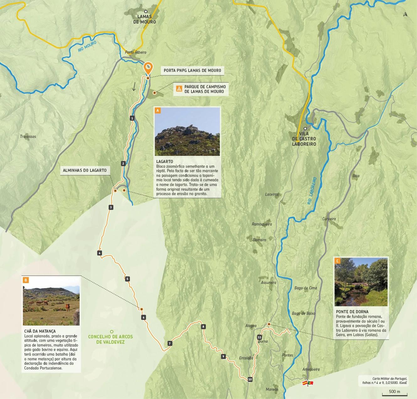
PR VIII: Lamas de Mouro - Dorna

The Lamas de Mouro – Dorna trail begins at the Lamas de Mouro PNPG Gate and ends at the Dorna Winter Park in Castro Laboreiro. The trail is approximately 12 km long and offers views of the natural, cultural, geological and scenic beauty of the entire trail. The trail initially follows the Mouro River, heading towards its source. On the left side, you can see the richness of the river’s riparian gallery; on the right side, at the top of the slope, you can see an outcrop of granite rocks. Several large granite blocks can be seen as a result of the rocks breaking off, deposited in isolation at the bottom of the valley. As you climb an old stone path that connected Lamas de Mouro to Peneda, you will come across the Lagarto Gate (A).
Looking ahead, a granite outcrop stands out and resembles a lizard, a figure that is the result of the alteration and erosion of the granite rock. Next to the road are the Alminhas do Lagarto, a vernacular religious heritage site. As you descend and cross the leafy oak forest, the presence of a high coverage of lichens covering the trunks of the oaks indicates very low atmospheric pollution and the high coverage of moss demonstrates the humidity of the place.
From here, a new climb begins that will lead to a flat area, Chã da Matança (B). A high-altitude meadow, with typical marsh vegetation, widely used by cattle and horses. Leaving the plain, the descent of the Serra da Peneda takes us to the valley of the Laboreiro River, where the Inverneiras are located. In the Dorna winter forest, one last point deserves to be highlighted, the Dorna Bridge (C). In Roman times, the area was crossed by a road that connected Portela do Homem to Terra-Chã, Mareco and Castro Laboreiro.
Fauna: Red-backed shrike (Lanius collurio), goshawk (Accipiter gentilis), Lusitanic newt (Chioglossa lusitanica)
Flora: Gerês lily (Iris boissieri), Peat gentian (Gentiana pneumonanthe), Holly (Ilex aquifolium)
Starting Point: Porta PNPG – Lamas de Mouro 42°02’20.7″N 8°11’45.0″W
Arrival Point: Dorna – Castro Laboreiro 41°59’34.9″N 8°09’42.2″W
Distance: 11,9 Km – Linear
Duration on Foot: 06h00
Duration on Horse: —
Duration on Bike: —
Difficulty: IV – hard
Max Height: 1080m
Min Height: 745m
Accumulated positive unevenness: 607m
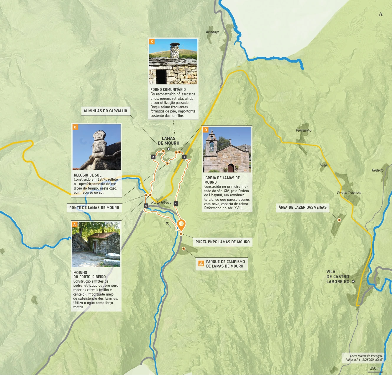
PR IX: Interpretativo de Lamas de Mouro

The Interpretive Trail begins and ends at the Lamas de Mouro Gate, one of the entrances to the Peneda-Gerês National Park (PNPG). Take the opportunity to visit this space dedicated to welcoming, entertaining, providing information and providing environmental education to visitors to the PNPG. Exhibitions and various interactive applications, with a strong visual and audio component, allow you to “travel” and discover the territory.
Once you start the walk, you will cross a small forested area and, at the same time, you will be able to admire the waterline of the Mouro River. The route continues towards the village of Lamas de Mouro, allowing you to understand not only the surrounding natural heritage, but also the entire cultural tradition associated with mountain life. The origins of this village date back to the Middle Ages. The hamlet emerged around the loving religious temple (D) that used to serve as a baptistery for the neighboring villages. Other testimonies remain that demonstrate the community life of the people, materialized in the picturesque Porto-Ribeiro bridge, the old Sundial (B), the Mill (A) and the Community Oven (C). All built in rough granite.
The last stage of the trail offers the opportunity to enjoy a landscape where areas covered by low vegetation stand out, with the Peneda mountain range as a backdrop. A short trail, but one that allows a very comprehensive view of different habitats (forest, riparian gallery, mountainous area and low scrubland), which reflects its important landscape and natural richness.
Fauna: Jay (Garrulus glandarios), Red Squirrel (Sciurus vulgaris), Blue Treecreeper (Sitta europaea)
Flora: Creeping Ground-buck (Centaurium portense), Foxglove (Digitalis purpurea), White Oak (Quercus robur)
Starting Point: Porta PNPG – Lamas de Mouro 42°02’20.7″N 8°11’45.0″W
Arrival Point: Dorna – Castro Laboreiro 41°59’34.9″N 8°09’42.2″W
Distance: 4,4 Km – Circular
Duration on Foot: 02h00
Duration on Horse: —
Duration on Bike: —
Difficulty: II – easy
Max Height: 940m
Min Height: 864m
Accumulated positive unevenness: 135m
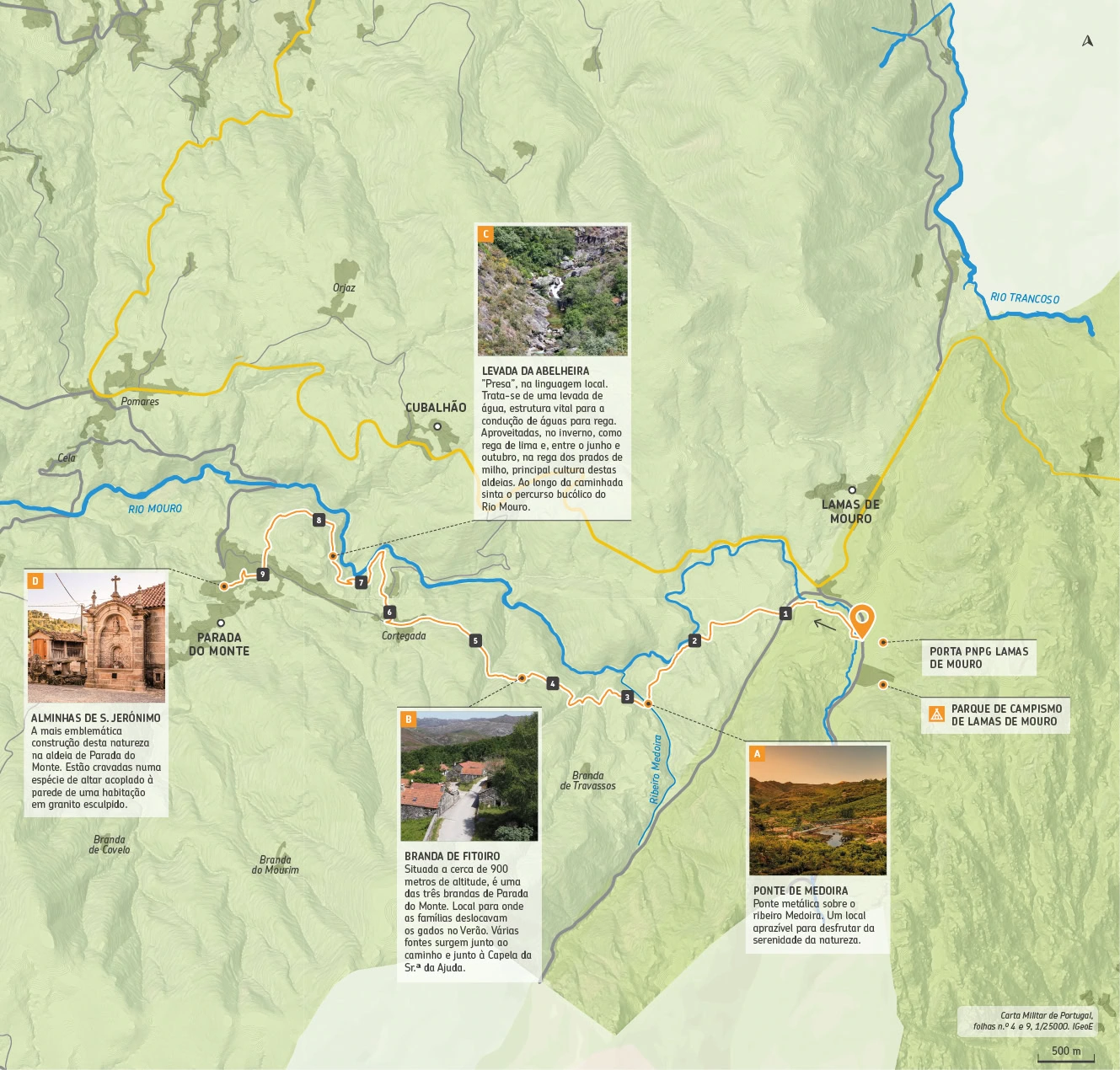
PR X: Lamas de Mouro - Parada do Monte

This trail runs from Lamas de Mouro to Parada do Monte. It is a route that follows, at some points, the course of the Mouro River, a tributary of the Minho River, which significantly shapes the terrain.
The path of the watercourse is pre-defined by the direction of the main fractures that affect the granite massif. Shortly after passing the ruins of the old Castro Laboreiro Dog Kennel, you cross the paved road and follow the dirt track that leads very close to the left bank of the Mouro River. A few metres further on, you cross the Medoira bridge (A), in Porto-Travassos, over the river of the same name, leading to the territory of Brandas de Travassos (around 1.2km from the trail) and Fitoiro, located at 950 and 900 metres above sea level, respectively. These fields were used in the summer (June-August) for cattle grazing, due to a lack of food in the village, since the fields were entirely cultivated. Both tell the story of the people of Parada do Monte and how they organized themselves as a community, adapting to the environment, and basing their subsistence model on agriculture and livestock farming.
Ao cruzar a Branda do Fitoiro (B) segue-se o caminho em terra batida, com um pequeno desvio pela antiga calçada, até ao lugar de Cortegada. Escassos metros de asfalto percorrido, vira-se à direita até junto da levada de água, uma estrutura vital para a condução de águas para rega. A água tanto é aproveitada no inverno, como rega de lima, evitando os estragos causados pelas fortes geadas e baixas temperaturas nos lameiros onde se cultivavam as ervas para fenar, como entre o junho e outubro na rega dos campos de milho ou para fazer mover os moinhos.
No final da levada da Abelheira (C) o caminho segue até à aldeia de Parada do Monte e termina junto Alminhas de S. Jerónimo (D) que são as mais emblemáticas da freguesia. Estão cravadas numa espécie de altar acoplado à parede de uma habitação e foi executada em granito esculpido, da autoria do mestre Manuel José Gomes (S. Paio, Melgaço, 1825-1901), mais conhecido na época como o “Mestre do Regueiro”.
Fauna: Corço (Capreolus capreolus), Poupa (Upupa epops), Milhafre (Milvus migrans)
Flora: Castanheiro (Castanea sativa), Gilbardeira (Ruscus aculeatus), Feto-real (Osmunda regalis)
Starting Point: Porta PNPG – Lamas de Mouro 42°02’20.7″N 8°11’45.0″W
Arrival Point: Parada do Monte 42°03’34.7″N 8°18’10.0″W
Distance: 9,3 Km – Linear
Duration on Foot: 04h00
Duraçtion on Horse: —
Duration on Bike: —
Difficulty: III – a bit easy
Max Height: 890m
Min Height: 565m
Accumulated positive unevenness: 249m
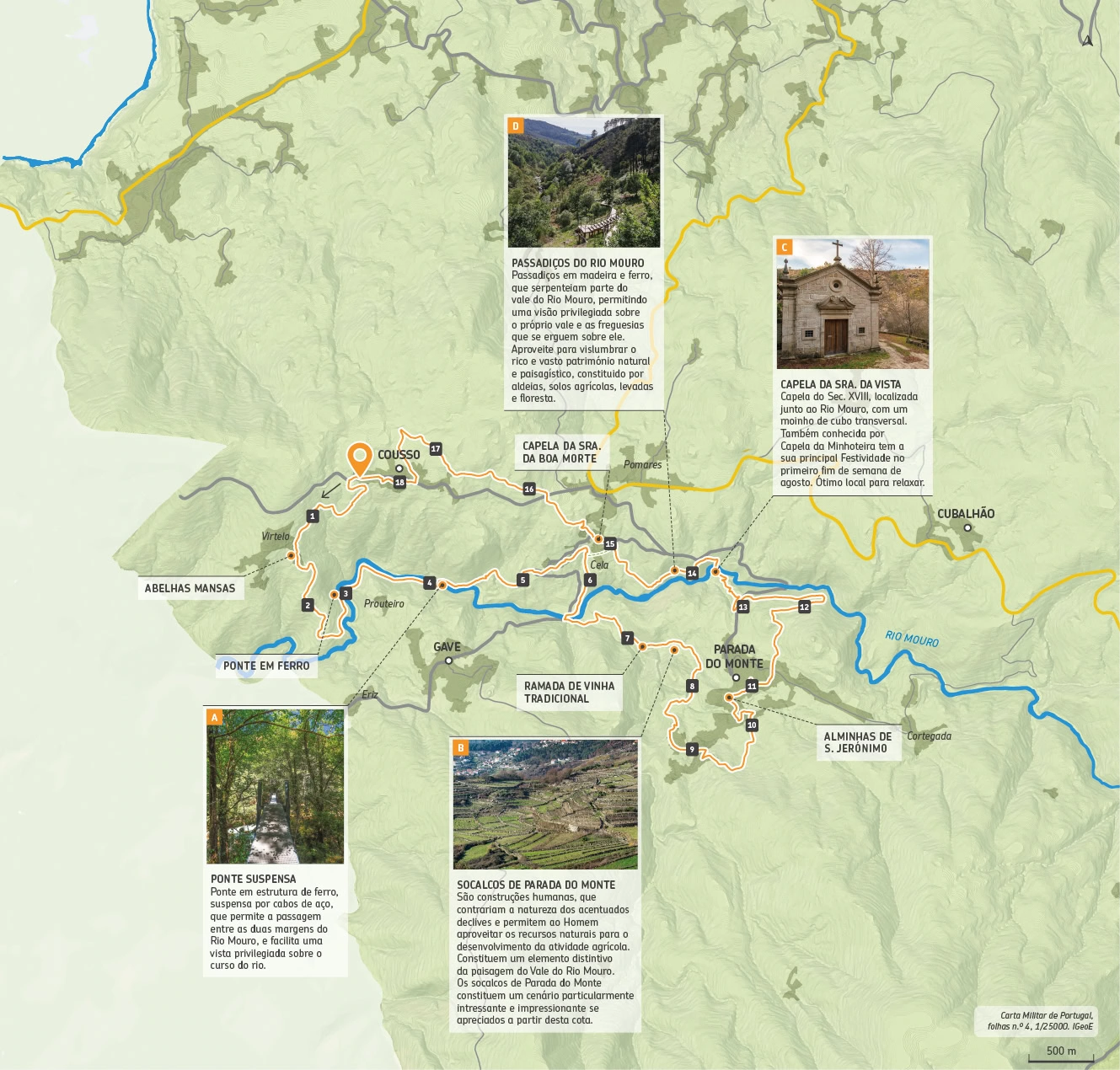
PR XI: Rio Mouro

Rivers are one of the most striking features of our landscapes. This trail, which begins next to the old primary school in Cousso, runs along the valley of the Mouro River, passing through the villages of Cousso, Gave and Parada do Monte.
The Mouro River begins in the town of Lamas de Mouro and runs for about 30 kilometres until it flows into the left bank of the Minho River, in the town of Ponte de Mouro, in the municipality of Monção. Along the way, it provides an interesting contact with a rich and vast natural and scenic heritage, sustained by crystal-clear, clear and refreshing waters and dotted with paradisiacal places that appeal to contemplation and relaxation. Following the directions, the descent allows you to get closer to the river banks, where the richness of its vast riparian gallery and great biodiversity stand out. Along its course, the Mouro River forms a valley (A), carved mainly on granite soils, with steep slopes, humanized from its base to the top.
Its importance, since ancient times, in helping the populations survive is attested by the humanization of the soils of the villages that are nestled there and that have an impressive set of terraces (C). Agricultural terraces are structures that contradict the nature of the slopes and allow man to develop agricultural activities in the most inhospitable places. Associated with them are crops of corn, grapevines (ramada) and an intense polyculture of varied vegetables.
The appreciation and preservation of these landscapes is essential for the prevention of natural risks. In Parada do Monte, be sure to recharge your batteries next to the Chapel of Sra. da Vista and Sr. dos Aflitos, also known as minhoteira (D) where you can enjoy a peaceful place with direct contact with the river and where the sound of the water and the cool shade invite moments of relaxation and replenishment. After crossing the Minhoteira pedestrian bridge, the trail takes you back to the starting point for two must-see tours.
Fauna: River trout (Salmo trouta), Water lizard (Lacerta schreiberi), Iberian frog (Rana iberica)
Flora: Black willow (Salix atrocinerea), Bracken fern (Blechnum spicant), Elderberry (Sambucus nigra)
Starting Point: Cousso 42°03’34.7″N 8°18’10.0″W
Arrival Point: Cousso 42°03’34.7″N 8°18’10.0″W
Distance: 18,4 Km – Circular
Duration on Foot: 06h30
Duration on Horse: —
Duration on Bike: —
Dificulty: V – very hard
Max Height: 664m
Min Height: 279m
Accumulated positive unevenness: 1004m
PR XII: Brandeiro

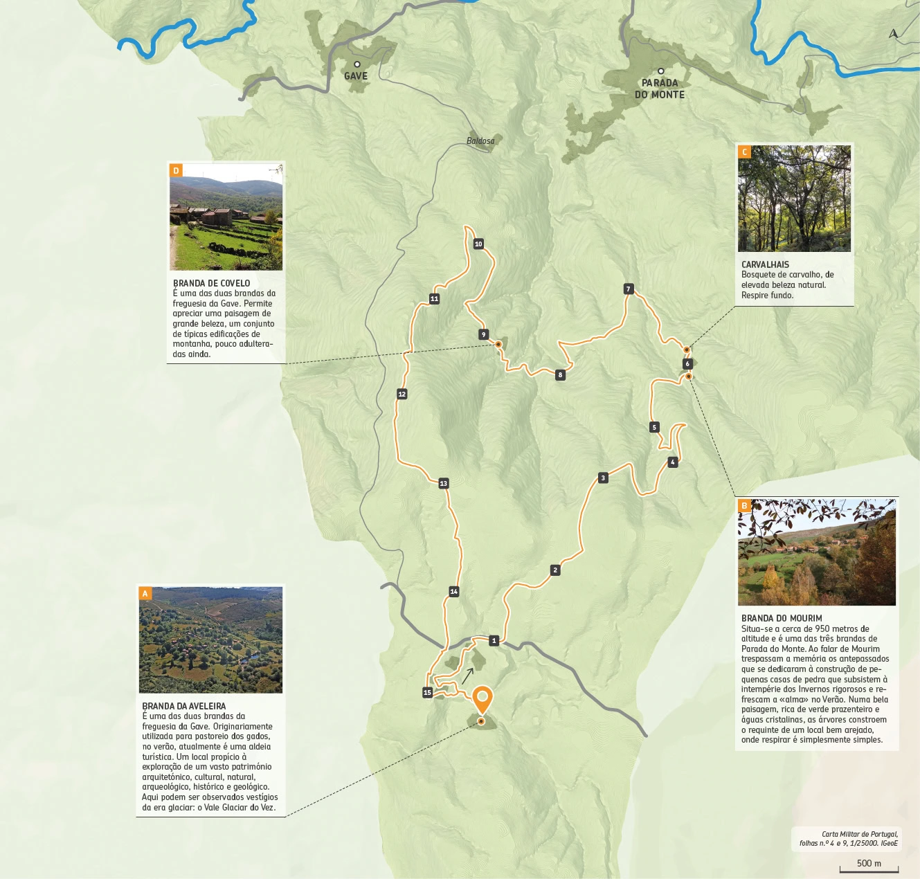
The Brandeiro Trail is located at the northern end of the Serra da Peneda. It covers part of the territory of the parishes of Gave and Parada do Monte, two villages with a strong tradition of transhumance (the seasonal movement of animals to places that offer better conditions during part of the year).
Brandeiro (the name given to the shepherd) would climb with his animals, leaving the lands located at lower altitudes available for the cultivation of corn and beans. The trail begins at Branda da Aveleira (A), next to a small and pleasant lake and then continues to the right (the preferred direction) towards Mourim. After crossing the paved road, you will travel along the Alto do Corisco plain (which gives its name to what was, at the time of its construction, the largest wind farm in the Minho region) from where you can see the extensive mountain ranges of Portugal and Galicia and the wide Minho valley, whose river has sculpted and shaped the relief of this mountainous region.
From an altitude of almost 1,200 metres, we descend to 950 metres where we can enjoy and rest in one of the three brandas of Parada do Monte. When we talk about Mourim (B), as with other brandas, we remember the ancestors who dedicated themselves to building small stone houses that survived the harsh winters and cooled the “soul” in the summer. We then follow the old path that connected Mourim to the village of Parada do Monte, along which we have the chance to cross a beautiful oak forest (C), of great beauty and natural value, which invites us to take a deep breath.
After the steep descent, you cross a small stream and reach the road again, which will take you through paths full of stories, to the Covelo branda (D), where you can also enjoy a landscape of great beauty and a set of typical mountain buildings that are harmoniously framed. After visiting this picturesque branda, the path takes you back to the starting point (Branda da Aveleira).
Fauna: Bullfinch (Pyrrhula pyrrhula) | Short-toed Eagle (Circaetus gallicus) | Sardão (Lacerta lepida)
Flora: Birch (Betula alba) | Pyrenean oak (Ouercus pirenayca)
Starting Point: Aveleira 41°59’41.0″N 8°16’48.7″W
Arrival Point: Aveleira 41°59’41.0″N 8°16’48.7″W
Distance: 16,2 Km – Circular
Duration on foot: 06h00
Duração a cavalo: —
Duration on Bike: —
Difficulty: IV – hard
Max Height: 1166m
Min height: 782m
Accumulated positive unevenness: 740m
PR XIII: Vale Glaciar do Vez

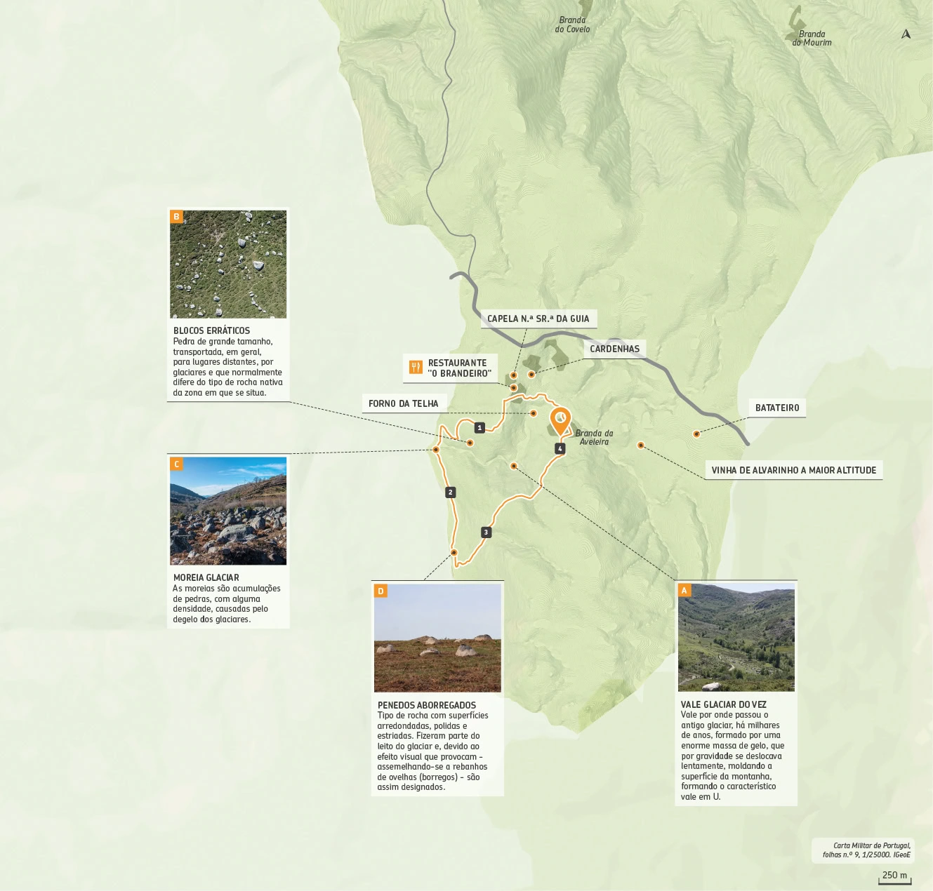
The Vez Glacier Valley Trail begins at Branda da Aveleira, a mountain plateau located at the northern end of the Peneda Mountains. The trail begins next to a small, pleasant lake and continues towards the chapel of Sra.
Many rock formations can and should be understood as so many documents of an even older history, processed over millions and millions of years. Within them resides the memory of Earth and Life and is part of our Natural Heritage. Currently, there are no glaciers in Portugal, but traces of their presence can be found. In the mountains of northwestern Portugal, glacial remains are very common, particularly in the Serra da Peneda, a mountain of great beauty, whose altitude reaches around 1,400 m, where traces of large icy masses resulting from the accumulation and compaction of thick layers of ice have been confirmed.
Geologically, schist predominates in the Aveleira branda. However, as you explore the area, you’ll find numerous traces of glacial deposits. Here, you’ll find frequently uneven boulders (D), polished and striated surfaces, moraines (C), till deposits, and erratic granite blocks (B) resting on schist. These are traces of the last glaciation of the Quaternary, the Wurm Glaciation. Some time after starting the hike, you’ll reach the confluence of the Aveleira River with the Vez River.
From here, you’ll gradually enter the valley through which the ancient glacier passed thousands of years ago. It was formed by a huge mass of ice that slowly moved under gravity, shaping the mountain surface, forming the characteristic U-shaped valley (A).
Fauna: Buzzard Eagle (Buteo buteo), Iberian Wolf (Canis lupus signatus), Fox (Vulpes vulpes)
Flora: Broom broom (Cytisus scoparius), Heather (Calluna vulgaris), Hawthorn (Crataegus monogyna)
Starting Point: Aveleira 41°59’41.0″N 8°16’48.7″W
Arrival Point: Aveleira 41°59’41.0″N 8°16’48.7″W
Distance: 4,3 Km – Circular
Duration on Foot: 01h45
Duration on Horse: —
Duration on Bike: —
Difficulty: III – a bit easy
Max Height: 1057m
Min Height: 918m
Accumulated positive unevenness: 202m
PR XIV: Aveleira

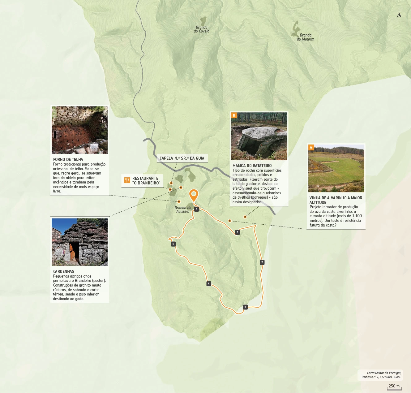
The Branda da Aveleira Trail is located in the Branda, which gives it its name, on a mountain plateau at the northern end of the Serra da Peneda. The trail begins next to a small, pleasant lake.
The toponym “Branda” derives from “Veranda,” meaning to spend the summer. Therefore, it is a temporary summer retreat, whose origins are part of a process of transhumance typical of agro-pastoral societies. Shepherds (Brandeiros) stayed here annually from late spring to late summer. During their stay, they built small shelters called “cardenhas” (cardenhas) where they spent the night. These were very rustic granite buildings, with two floors and a single-story structure, with the lower floor reserved for livestock.
Segue-se por um caminho ladeado por muros de pedra solta, vulgarmente chamados de «canejas» (A), que delimitam as propriedades privadas. Numa destas propriedades de cerca de 2,5 hectares, fruto de um projeto inovador, ainda recente, a Quinta de Soalheiro, “primeira marca de vinho alvarinho de Melgaço”, plantou, às portas do Parque Nacional da Peneda-Gerês, a mais de 1.100 metros de altitude, a vinha de alvarinho a maior altitude de Portugal. O caminho florestal conduz-nos depois a um pinhal e, nas suas imediações, podemos encontrar a mamoa do Batateiro (B), um monumento megalítico de razoáveis dimensões, com significativos vestígios estruturais, no que concerne a câmara dolménica, constituída por sete esteios.
Na superfície interna do esteio da cabeceira detetam-se ténues vestígios de gravuras. Ao percorrer a extensa paisagem de montanha surge uma charca, onde inúmeros animais domésticos de raças autóctones acorrem para saciar a sede. Depois de uma pequena subida, inicia-se a descida até ao ponto de partida, atravessando a Branda.
Fauna: Lobo Ibérico (Canis Lupus Signatus), Javali (Sus scrofa), Raposa (Vulpes vulpes)
Flora: Tojo molar (Ulex minor), Piorno (Genista florida), Erva-das-sete-sangrias (Glandora prostrata)
Starting Point: Aveleira 41°59’41.0″N 8°16’48.7″W
Arrival Point: Aveleira 41°59’41.0″N 8°16’48.7″W
Distance: 6,1 Km – Circular
Duration on foot: 02h45
Duration on Horse: 00h30
Duration on Bike: 00h45
Difficulty: II – easy
Max Height: 1172m
Min Height: 986m
Accumulated positive unevenness: 215m
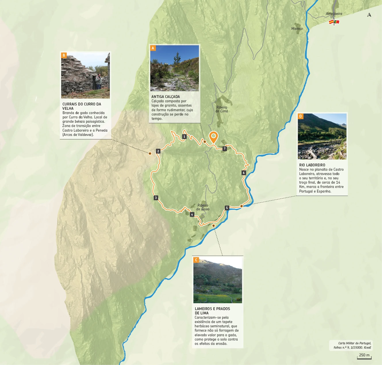
PR XV: Curro da Velha

This is the only route that, due to its location, doesn’t have a trail connecting to the network, requiring you to travel by road to the starting point.
Therefore, from the village of Castro Laboreiro, follow the signs toward Ribeiro de Cima until you reach Pousios. On the right side of the road is an old park ranger’s house, and on the left side of it, along a sidewalk (A), the trail begins. Gradually ascend to the “currais” (currals) – a cattle drive known as Curro da Velha (Old Woman’s Curry) (B).
From these mountain pastures to the small plain (Chão da Roca), wild landscapes emerge, amidst the green of the vegetation and the gray of the granite. Through the broom, you continue along a trail opened by the passage of cattle, which gives way to a paved path. This section of the route, which follows the watercourse, must be extremely careful due to the steep incline. A few meters below, the path leads to Ribeiro de Baixo, a place nestled in the bottom of the Laboreiro River valley (D), where the landscape is reminiscent of alpine environments. The opportunity to appreciate a landscape marked by terraces is unique. These structures contradict the nature of the slopes and allow humans to carry out agricultural activities in the most inhospitable places. The appreciation and preservation of these landscapes is essential for preventing natural hazards.
Continue upriver along a cool path that will lead to the typical Castro village of Pousios. You’ll glimpse marshes and hay meadows (C), which reach their full splendor between May and June, their multicolored colors highlighting their diverse flora. Soon, you’ll return to the old forest house, where this beautiful journey through Castro lands began.
Fauna: Seoane viper (Vipera seoanei), wood lizard (Psammodromus algirus), tawny owl (Strix aluco)
Flora: Stormfly (Thymus caespititius), gorse (Pterospartum tridentatum), Portuguese lily (Paradisea lusitânica)
Starting Point: Pousios – Castro Laboreiro 41°57’51.5″N 8°11’00.2″W
Arrival Point: Pousios – Castro Laboreiro 41°57’51.5″N 8°11’00.2″W
Distance: 7,3 Km – Circular
Duration on Foot: 04h30
Duration on Horse: —
Duration on Bike: —
Difficulty: V – very hard
Max Height 1007m
Min Height: 575m
Accumulated positive unevenness: 522m
Percursos Marginais do Rio Minho
The River is the highlight of this pedestrian circuit, starting in the Village, next to Alameda Inês Negra, it develops towards the Internships Center and the River, passing through a zone in the Rede Natura, finishing finally, next to the Termas do Peso
Promoter: Municipality of Melgaço
Route Type: Short Route (PR)
Location: Vila, Prado, Remoães, and Paderne
Route Scope: Scenic
Distance: 5.7 km
Route Duration: 1h30
Difficulty Level: Low
Minimum/Maximum Altitude: 53/177 m
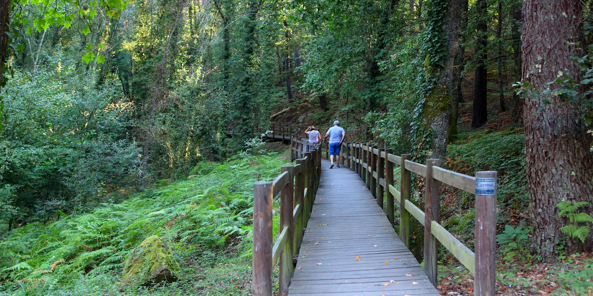
From our gallery


