Cycling

For the street cycling lovers, Melgaço is a true paradise on wheels. With dozens of kilometers of roads well preserved, the region offers challenging courses, hard climbs and breathtaking views. Ideal for intense training, leisure walks or preparation internships. Melgaço is also home to nacional and international competitions. The county offers cyclists helping infrastructures, also as resting zones, washing points, quality signaling and technical assistance.

Circular route with an extension of 18,2 km and 357 meters total of unevenness, ideal for training in the mountain environment or calm nature walks. Starting in Lama de Mouro, next to the Parque Nacional da Peneda-Gerês reception center, the track unveils a progressive climb, alongside wide and calm views witch characterize this preserved zone.

The route passes through the Várzea Travessa and Vido villages, where you’re able to enjoy the typical rural architecture and witness the clear landscape of the valley around. The top moment of the circuit it’s the arrival at Castro Laboreiro, passing the region’s  Interpretive Center and church, located in the village’s history center, where history and tradition are felt in every step.

The return to Lamas de Mouro it’s done through a good quality road with low traffic. mainly going down, offering and a comfortable, safe and fluid final part of the track.

Throughout the circuit, it´s possible to witness the local wildlife of the Parque Nacional da Peneda-Gerês. Between the more common animal species there are the garrano, the roe deer, the boar and several birds like the common buzzard.  The plants are mainly oak trees, heather and other local species, that contribute to the ecological and beautiful wealth of this mountain territory

Starting point and Arrival: Lamas de Mouro 42°03’04.0″N 8°11’58.3″W
Distance: 18,2 Km – Circular
Rating: Green
Max Heigh: 1104m
Min Height 859m
Total positive unevenness: 357m

A 30.8 km circular route with a total unevenness of 785 metres, demanding and full of scenic interest, ideal for experienced cyclists looking for a challenge in the middle of nature. The route starts in Lamas de Mouro, in the Peneda-Gerês National Park, and continues with a long climb to Castro Laboreiro, crossing forested areas and open zones that allow you to admire the diversity of the mountain landscape.

Upon reaching Castro Laboreiro, the route crosses the centre of the village, passing the main church and several elements of its rich historical and cultural heritage. The descent that follows leads to the village of Assureira, a place with a strong rural identity, marked by traditional stone buildings and terraced fields.

The route continues towards the Ameijoeira area, close to the border with Spain, where impressive granite formations and steeper sections stand out, which test the cyclists’ technique and endurance. The return to Lamas de Mouro is via a secondary road with good pavement and little traffic, alternating between short climbs and more technical descents, providing a dynamic and engaging finish.

Along the route, it is possible to observe the rich fauna and flora of the National Park. Animals such as the garrano, roe deer, wild boar and birds such as the golden eagle and kite live in these mountains. The vegetation is composed of oak forests, broom, heather and other native species that contribute to the beauty and ecological diversity of this mountain landscape.

Starting Point and Arrival: Lamas de Mouro 42°03’04.0″N 8°11’58.3″W
Distance: 30,8 Km – Circular
Rating: Blue
Max Height: 1015m
Min Height: 713m
Total positive unevenness: 785m

This 28 km circular route, with 1006 metres of total unevenness, is a demanding route designed for experienced cyclists looking for a technical and scenic challenge in the heart of the Peneda-Gerês National Park. The route starts in Lamas de Mouro, heading towards the Batateiro plateau, a high-altitude area marked by wide mountain landscapes and trails with a strong natural character.

The route then passes through the village of São Bento do Cando, insrted in the Peneda mountains, where the traditional granite architecture and rural surroundings reinforce the region’s identity. From there, the route continues to Gavieira and Rouças, with steep climbs and stunning views over the deep valleys and steep slopes of the mountains.

The final part of the route takes cyclists to the emblematic Senhora da Peneda, one of the highlights of the route, where the effort is amply rewarded by the view of the sanctuary and the majestic scenery of the Serra da Peneda. The return to Lamas de Mouro is made along mountain paths, ending a challenging circuit that combines physical effort with total immersion in nature.

Along the route, it is possible to encounter a great diversity of fauna and flora. Species such as the garrano, roe deer, wild boar and birds such as the golden eagle or the peregrine falcon are common in this area. The vegetation is dominated by oak forests, heather, broom and high-altitude scrubland, which contribute to the ecological and scenic richness of this protected area of ​​Alto Minho.

Starting Point and Arrival: Lamas de Mouro 42°03’04.0″N 8°11’58.3″W
Distance: 28 Km – Circular
Rating: Blue
Max Height: 1104m
Min Height: 548m
Total positive unevenness: 1006m

With a length of 38.2 km and a total unevenness of 1,200 meters, this highly difficult route is recommended for experienced cyclists looking for a true technical and physical challenge in the mountains. The route begins in Lamas de Mouro, in the heart of the Peneda-Gerês National Park, heading towards the Batateiro plateau, along open trails that reveal the vastness of the mountain landscape.

The route continues towards Branda da Aveleira, one of the best-known brandas in the region, where traditional agricultural practices are still preserved. From there, the route descends to the village of Gave, with views of the deep valleys and wooded slopes, before tackling the most demanding section of the route: the long and constant climb to Pomares. This section, surrounded by the imposing silence of the mountains and virtually untouched nature, offers a unique experience of overcoming and contemplation.

The last part of the route heads towards Lamas de Mouro, with a challenging final climb that, despite the effort, is compensated by panoramic views of the mountains and the serene and isolated mountain environment.

Along the route, it is possible to observe a wide variety of fauna and flora characteristic of the National Park. Garranos, roe deer and wild boar are frequent sights, as are birds of prey such as kites and golden eagles. The vegetation is dominated by native oak forests, broom, heather and high-altitude scrub, which reinforce the wild and authentic character of this mountain region.

Starting Point and Arrival: Lamas de Mouro 42°03’04.0″N 8°11’58.3″W
Distance: 38,2 Km – Circular
Rating: Red
Max Height: 1080m
Min Height: 332m
Total positive unevenness: 1200m

With a length of 102 km and a total unevenness of 3,418 metres, this is a high-level route designed for experienced cyclists looking for a true test of physical and technical endurance. The route begins in Lamas de Mouro, in the Peneda-Gerês National Park, and continues towards Fiães, where the imposing Fiães Monastery stands out – a historical landmark of great architectural and spiritual value.

From Fiães, the route continues to Cevide, the northernmost point of mainland Portugal, where Portugal’s landmark number 1 is located, close to the border with Galicia. From there, you enter the town of Melgaço, an ideal place for a short break before continuing on to Peso, known for its thermal baths, and the wine-growing villages of Alvaredo and Paderne, in the heart of the Alvarinho wine region.

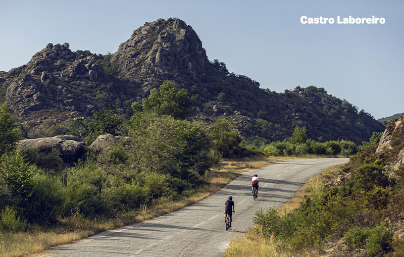
The challenge increases on the climb to Estivadas, one of the most challenging on the route, which takes cyclists through landscapes of rare beauty. The route continues through Pomares, Cubalhão and Parada do Monte, mountain villages with a strong rural identity, until reaching Branda da Aveleira, where the tradition of brandas meets the impressive views over the valleys and mountains of the region.

The return to Lamas de Mouro marks the end of a challenging and memorable journey, which combines physical effort, diverse landscapes and a deep contact with the history, culture and nature of the municipality of Melgaço.

Along the route, it is possible to spot several species from the local fauna, such as the garrano, roe deer, wild boar and large birds such as the golden eagle and the black kite. The flora follows the altitudinal and landscape diversity, with oak forests, vineyards, broom, heather and native woodlands that highlight the ecological richness and authentic character of the territory.

Starting Point and Arrival: Lamas de Mouro 42°03’04.0″N 8°11’58.3″W
Distance: 102 Km – Circular
Rating: Black
Max Height: 1104m
Min Height: 72m
Total positive unevenness: 3418m

Remaining cycling trails coming soon

From our gallery